Gudbrandsdalsleden: Oslo - Trondheim
Photo: Eskil Roll
Oslo - Gjøvik/Hamar - Trondheim
Difficulty:
Easy, medium, demanding, depending on whether you walk the whole way or just a section of it.
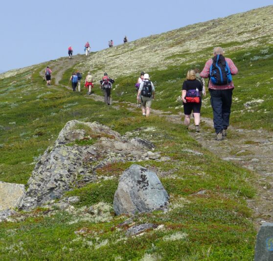
Type of terrain:
The trail is long and is therefore very varied. You will walk both on asphalt, forest paths and in mountain terrain.
Recommended hiking period:
It is recommended to walk the Gudbrandsdalsleden trail in summer between 1st June and 1st September to avoid snow and meltwater. The accommodations may be closed off-season. On the Dovrefjell mountain range, the snow can last longer, therefore you should not cross Dovrefjell by foot before June 10th, take the train instead. This is also to avoid disturbing the wild reindeer during calving.
The Gudbrandsdalsleden trail is Norway's longest hiking trail. This was the main road from Oslo to Nidaros (the old name of Trondheim) in the Middle Ages and is one of the most visited and developed pilgrimage routes in Norway. The trail is suitable for most people, it is well marked and can be walked in stages or as one long hike. It is also easily accessible by public transport like train.
The trail starts at the ruins of St. Hallvard Cathedral in Oslo. Here you'll find the milestone that shows that you have 643 kilometers in front of you if you are going to go all the way to Trondheim. You can choose between the eastern or western route past Lake Mjøsa, or combine the two by taking the world's oldest wheeled steamer and official pilgrimage boat, Skibladner. The first part of the trail goes through the city, cultural landscape and forest.
The two routes meet again in Lillehammer and here the Gudbrandsdalen valley begins. The pilgrim route runs here along the river Gudbrandsdalslågen in partly sloping terrain.
The trail continues further up on Dovrefjell, up to 1200 masl. The area is dominated by mountain scenery, it is sparsely populated and there is no direct local supply during the next 100 km to Oppdal.
From Oppdal to Trondheim, it is mostly forests and cultural landscapes that characterize the trail.
Here you'll find more information and advice about the Gudbrandsdalslden path.
Experiences along this route
-
Cultural Heritage
Oslo - starting point
Gudbrandsdalsleden, Tunsbergleden, Borgleden -
Church
The Memorial Park / The St. Hallvard Cathedral
Gudbrandsdalsleden, Borgleden, Tunsbergleden -
Transport
The pilgrim boat Skibladner – the port at Gjøvik
Gudbrandsdalsleden -
Transport
The pilgrim boat Skibladner – the port at Hamar
Gudbrandsdalsleden -
Church
The Sister Churches
Gudbrandsdalsleden -
Church
Hamardomen
Gudbrandsdalsleden -
Church
Ringebu Stave Church
Gudbrandsdalsleden -
Cultural Heritage
Allmannrøysa
Gudbrandsdalsleden -
Cultural Heritage
Vesle-Hjerkinn
Gudbrandsdalsleden -
Church
Rennebu Church
Gudbrandsdalsleden -
Key Location
Nidaros Cathedral
Gudbrandsdalsleden, St. Olavsleden, Kystpilegrimsleia, Østerdalsleden, Romboleden
Useful reading
Routes nearby
[[ notice ]]
We found no trail suggestions.
Try to filter on something else.