Tynset - Trondheim | Østerdalsleden stage 2
Day 1: (19 km) Tynset - Vingelen
The journey begins in the center of Tynset. Østerdalsleden passes close to the train station and goes through the town center towards Tynset church and the milestone. Shortly after passing Tynset church, the journey will continue towards Vingelen along "Gamle Allmannsvei". An old road between Tynset and Vingelen. Already in the 17th century, this stretch of road had become a cart road, and is probably the oldest cart roaf in the region of Hedemark. The highest point is Vesleåsen hill at 788 meters above sea level.
Accommodation before/in Vingelen:
Day 2: (28 km) Vingelen - Dalsbygda
The journey from Vingelen to Dalsbygda is the first longer leg of the journey. Østerdalsleden follows the road for approx. 4 km before the trail takes off on the path at Austvangen. The trail rises steadily through the forest, goes below Austvanggårdene and continues on easy terrain between the hills: Vangsåsen and Kottberget, down towards Tallsjøen. At "Allmannhaugen", the medieval road turns towards Båttjønna and continues into Os municipality. Motorway the last stretch to Dalsbygda.
Note that Joker Dalsbygda is the last grocery store before Singsås
Accommodation before/in Dalsbygda:
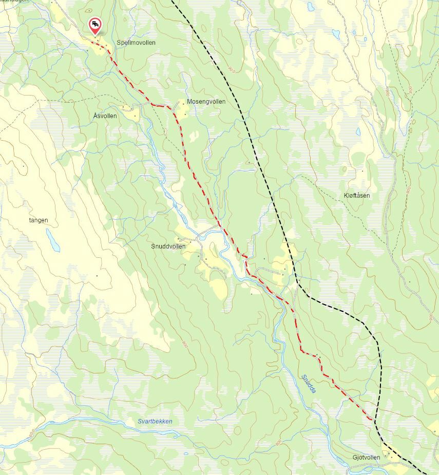
Day 3: (20 km) Dalsbygda - Såttåhaugen
This is the stage that moves towards Forrolhogna National Park. Hikers must be prepared that they will spend large parts of the next three days in the wilderness with very long day stages. Today's stage begins along the road for 7 km before the trail then turns onto a path with a gentle climb up through the Valley: Vangrøftdalen. Afterwards, the surface alternates frequently between trails and dirt road on the way up towards Forrolhogna.
To make it easier to get to Spellmovollen for the night, you can leave the trail a little earlier at Gjotvollen and follow the road north to the pastiures at Såttåhaugen (see map). At Spellmovollen you can get accommodation with traditional food on order. Såttåhaugen lies at 900 meters above sea level and is the gateway to the Forollhogna National Park.
Accommodation at Såttåhaugen:
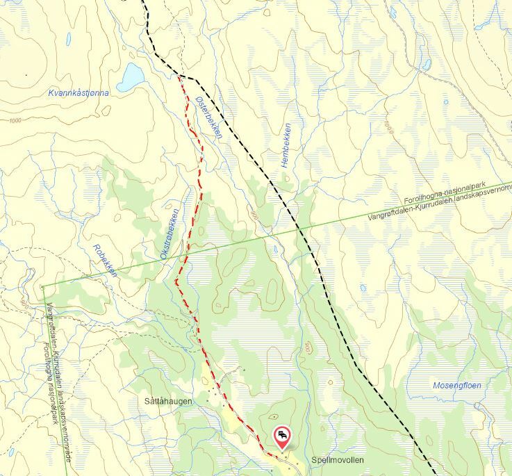
Day 4: (25 km) Såttåhaugen - Storbekkøya
The Østerdalsleden passes above Såttåhaugen and Spellmovollen on the east side. It is possible to follow a tractor road/path from Såttåhaugen which returns to the Österdalsleden after 3 km by the pond Kvankåstjønna (see map).
Furthermore, the trail follows an old footpath on fantastic high mountains between the lake Forollsjøen (1,000 m) and Forollhogna (1,332 m). On the road to Storbekkøya, there are several cabins available as accommodation. If the weather is nice, an extra night on the mountain is recommended.
Accommodation
Day 5: (27 km) Storbekkøya Museumsseter - Singsås
The østerdalsleden follows roads further into the valley. After passing the farm Storli, the mountain trail begins up to Tåvåfjellet. The path crossing the mountain is called the old "Kjørkvegen" (the church road). This leg starts with a demanding climb through the forest. Up over the tree line, the østerdalsleden passes old "Sæterstøler" (mountain patures), and the idyllically situated Pilgrimsbu Vardan. Tired hikers can spend the night here. Later the descent towards Singsås begins.
Note that Coop Prix Singsås is the last grocery store before Trondheim, if you do not plan to visit the grocery store Coop Prix Ler.
Accommodation at Singsås:
- Kari Maries Sommerresidens
- Storstu Winstnes
- The tool house | Singsås Stave Church
Day 6: (23 km) Singsås - Samatun
The first destination for the day will be the Stave Church in Singsås. (You can also follow the rørosveien straight out of Singsås if you don't want to visit the stave church). This old church site probably had a standing church here already 800 years ago. The Østerdalsleden follows an asphalt road out of Singsås until you turn off at Samsjøveien to the north towards the farms on Øfsti Digre. After walking approx 5 km on the gavle road the path goes off clearly to the left. The path goes through forest and over marshes partly along the river Seville, before you finally reach the pond Sevilltjønna at the foot of the mountain Burufjellet. But for today's break, it's recommended that you head up to the Pilgrimsbua at Okstjønna. For tired pilgrims, this can be a good option for accommodation. You end the day by walkning over Samsjøvola, with the lake Samsjøen on the right side of the trail. The last part above Samsjøvola is on high mountains. The trail then descends to Samatun.
Accommodation at Samatun:
Day 7: (28 km) Samatun - Fremo - Kirkflå / Ler
One of the longer stages of the journey will take the pilgrim through a beautiful hilly forest terrain. In this area there are several interesting cultural and historical sites. First you come to St. Olavsknippen, a place notorious for its old myths and legends. After the trail passes the pond Austtjønna, the trail goes along a gravel road down towards Fremo. Along this dirt road, there are small stages that follow the old road: Rangåveien, an idyllic old Trail that can provide some relief from walking on a hard dirt road. A short distance along the gravel road, you reach Heimvollen. Here it is possible to get accommodation approx. 10km before overnight in the forge at Kirkflå if necessary. The trail continues past Fremo Leir and on to Kirkflå. Kirkflå has been of great importance to the inhabitants of Melhus since ancient times, and was once the church site of the municipality.
At Ler below Kirkflå you will find the grocery store Coop Prix Ler. Distance from Østerdalsleden is 2.5 km.
Accommodation at Kirkflå
Day 8: (15 km) Kirkflå /Ler - Rødde
The day starts steeply and boggy. But after a few km, it flattens out and it becomes easier to walk. The Østerdalsleden passes over the mountain Vassfjellet by the pond Øyvindtjønna. At the highest point of the stage(520 m), by Øyvindtjønna there used to be a chapel in the Middle Ages. Close by flows St. Even's spring, which the stories tell of miraculous water. For the Østerdalsleden, this place is also called feginsbrekka (hill of joy), since this is the first place where it is possible to catch a glimpse of Nidaros Cathedral, the final destination of the pilgrim's journey. At Øyvindtjønna there is also a small hut with 2 benches. (Sælehus) A good restingplace, but not recommended for overnight stays. From the top the path leads down through the forest to Rødde.
Accommodation at Rødde:
- Oppigard Havdal
- Birgittaklosteret | Tiller (+7 km past Rødde)
Day 9: (18 km) Rødde - Trondheim
The last day begins on a paved road uphill before turning off onto a dirt road after a roundabout. From here, the trail goes mostly on dirt roads and paths through cultural landscapes down to the river Nidelven. Then the last leg of the Østerdalsleden follows the river. Along the way, the pilgrim will reach Øvre- and Nedre Leirfoss. Old power plants, which have supplied the Trondheim region with electricity. From Nedre Leirfoss, the trail follows a "green vein" along the river into the city centre. Finally, the trail goes in an urban environment, past Lerkendal, St. Olav Hospitals and finally over the Elgsæter bridge with a great view to Nidaros Cathedral and the end of the journey.
Visit the pilgrim reception in Nidaros Pilgrimsgård, so that you can register your completed walk, get the last stamps in your passport and a badge that gives you free entry into Nidaros Cathedral.
Accommodation in Trondheim:
- Nidaros Pilgrimsgård | Pilgrim Center Trondheim
- The pilgrimage Town of Trondheim
Preparations | Recommended footwear
This reconmended hike is extra demanding. Pilgrims who choose to walk the Østerdalsleden must be well prepared both physically and in terms of equipment. There will be parts of this trail that are poorly marked, and general knowledge of maps and orientation is recommended. The journey goes through areas with poor mobile coverage, and you cannot therefore reliably rely on a digital map on a mobile phone. It is recommended to buy a paper map of Forrolhogna National Park and of Samsjøvola in Singsås and Melhus.
The Østerdalsleden trail moves over mountains and through deep forests with less prepared paths. The editor's recommendation for footwear would be marching boots that handle marsh and forests, as well as having softer soles for the longer stages on roads and dirt roads. Note that mountain boots tend to have stiff soles, which can be demanding to use along roads. However, always choose well-worn footwear over new "optimal" footwear. Read more about preparations here.
Recommended period:
June to September
Arrival Tynset:
- Train or bus to Tynset Station
Departure Trondheim:
- Train, bus or plane from Trondheim
Experiences along this route
-
Accommodation
Trollhaugen cabin
Østerdalsleden -
Accommodation
Tynset Rom & Camping
Østerdalsleden -
Cultural Heritage
Vingelen Church- and School Museum
Østerdalsleden -
Accommodation
Vingelsgaard Guest House
Østerdalsleden -
Accommodation
Meierigården
Østerdalsleden -
Accommodation
Spellmovollen mountain farm
Østerdalsleden -
Accommodation
Cabin | Storbekkøya Museumssæter
Østerdalsleden -
Accommodation
Samatun
Østerdalsleden -
Accommodation
Heimvollen
Østerdalsleden -
Accommodation
The Old Smithy at Kirkflå
Østerdalsleden -
Accommodation
Pilegrimsbu by Okstjønna
Østerdalsleden
Routes nearby
[[ notice ]]
We found no trail suggestions.
Try to filter on something else.